Login
Sign UpLoginSign Up
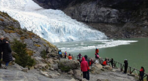
Live the adventure in the southernmost circuit of the world, an extraordinary place, full of unspoiled nature, surrounded by rivers, lakes and impressive mountains, enjoy the trekking teeth of navarino
7 days / 6 nights program on Navarino Island, which includes the 4-day trek through the southernmost forests, the most inhospitable peaks, and one of the most pristine places on the planet.
Important: The reservation is made with a minimum of 4 weeks in advance and according to availability in flights or navigation.
10 am Carlos Ibañez del Campo International Airport (Punta Arenas)
8am Navigation from Ushuaia to Puerto Navarino

This program is under the all-inclusive regime. This means that it contemplates the flight of entry and exit of the island, three nights in a family hostel double room (one before the trekking and two after) with breakfast, a briefing lunch and a celebration dinner, four days of trekking (with possibility that are finally five due to climatic conditions, pace of the explorers, etc.), guide, a carrier every two people satellite phone, food during the trekking, mountain material (sacks, tents for two people, mattresses, earthenware, gas) . Transfers are also included at the beginning and end of the trekking, and to the airport.
One day before starting the expedition we will get together to receive the technical talk of what will be our next days of adventure in the Teeth of Navarino trekking. After the meeting, we will deliver sleeping bags, mats and walking sticks so you can put it in your backpack, as well as walking rations. The heaviest items such as tents and food, as well as kitchen utensils will be carried by our team.
(Distance 11 km – Slope 600 m – Time 6-7 hours)
We begin the adventure in the city of Puerto Williams where the minibus will pick up the passengers at their respective places of accommodation, from there we head to the water intake (starting point).
This starting point of the trek has a cabin that acts as a Tourist Information Office and CONAF Office, and has public toilets, the last glimpse of civilization that you will find in the next few days.
We ascend about 3.5 kms away with an altitude of 550 meters. In this first section (you will immerse yourself for the first time in the subantarctic native forest, and you even have viewpoints and benches to rest. With a good step, you will leave the forest and reach Cerro Bandera, where you will see impressive views of the Beagle Channel.
From this moment you will walk practically the rest of the day in the Andean highlands, along the eastern slope of the Róbalo valley, whose slope will put explorers who suffer from vertigo to the test. In this place you can feel the wind coming, and in these cases you have to be careful not to stick well to the wall or the ground. When you have the Laguna del Salto in view of a condor, you will go down the first haul of the circuit, rocky and unstable gravel, until you reach the foot of the Laguna.
In this place we will spend the first night to find running and clean water in the surroundings, as well as some sectors with flat and dry surfaces.
(Distance 9 km – Slope 500 m – 5-6 hours)
We leave early to go bordering the Laguna del Salto, and where we will cross the first stream. The second small tributary, which runs through a steep ravine, will be the “trail” to continue. Continuous ascent that will wet our boots from the beginning of the day, and that brings us closer to the high peaks of the Dientes de Navarino. El Paso Primero, of extraordinary beauty, will not leave you indifferent: at this height it is common to find snow even on summer days, and the only glimpse of life you will find will be a few cushion plants.
You will continue ascending to what would be the pass that marks the end of the Róbalo valley, known as Paso Australia, and from which you will see the Laguna del Paso on the other side. The body of fresh water must be passed through the slope on the right, with a vertiginous slope, constituting one of the most complicated places on the circuit. It is important to mention that outside of the summer season this place is covered with a layer of ice that makes it impossible to pass without special equipment (ice axes, crampons and others). If during the summer you find the rocks with water, snow or ice as a result of the rain and a cold night before, our advice is to wait to pass this place in the afternoon, when the temperature during the day has improved the conditions of the sector.
Crossing this place, known as the Paso de Los Dientes, means crossing to the southern sector of Navarino Island. From here, if the weather is good, you will be able to observe the landscape that surrounds the Windhond Lake and Bay, and further south even Nassau Bay or the Cape Horn archipelago.
The rest of the day is a “rose path” on flat terrain and a gentle descent, leaving the Picacho lagoon on your right side, and the Picacho de los Dientes on the left, with more than a thousand meters of height (1118 meters above sea level). The third of the lagoons, in its southern part, allows us to see the Valley of the path that constitutes the Heritage Route of Lake Windhond. At this point you will have to turn right (heading east) to the Laguna de los Dientes, a place where we recommend that you make your second camp.
Overnight: The Laguna de los Dientes and Cerro Gabriel sector has exposed places near the lagoon (if the weather is good, waking up in front of the lagoon is a gift) and others in the forest, somewhat more protected from weather conditions adverse.
(Distance 7 km – Slope 300 m – Time 5-6 hours)
The path continues bordering Laguna de los Dientes, which will always be on your left, until you leave Cerro Gabriel on the other side. From there you will continue through the valley that appears on the right, with scrubby forest and peat bogs. The Laguna Escondida is another of the typical postcards of the Dientes de Navarino, you will have to skirt it, leaving it on your right and following a stream later, until you cross it through a beaver dam. Following the valley to the end and having passed the copses, you will come across, with hardly any vegetation left, a boxed-in lagoon. The steep climb of rocks that ends at Paso Ventarrón leaves us with a picture of contrasts as we observe to the south a green valley full of lagoons and beaver dams, and to the north (where you came walking from a few minutes ago), the hostile peaks of the Cordon de los Navarino teeth.
From this pass you have to change to a west course (turn to the right) bordering on a slope of gentle ascent for a few minutes, and then a slight descent that is longer in time. The entire rocky slope is usually very exposed to strong gusts of wind, so you should take extreme precautions to avoid frights, until at a lower level the valley also protects you with more bushy and wooded environments.
Bordering the last lagoon, which is also a beaver, you will arrive at the foot of Paso Guerrico, a sheltered place from which you will begin to ascend through a forest of twisted trees first, and bedrock covered in large areas by cushion plants later. From Paso Guerrico, the valley offers beautiful views with the Laguna Hermosa in the immediate vicinity, which you will leave on your right, and the necessary orientation to continue the path down for the next few hours.
Overnight: The Laguna Martillo in its southern part, that is, the sector of the lagoon that we will reach first, offers some flat places in which to pitch the tent. It will be difficult but not impossible to find dry places.
(Distance 10 km – Drop 600 m – Time 6-7 hours)
Before starting to walk this day, stand in front of Laguna Martillo and observe the hills that guard it. The imposing Cero Clem next to the Lindenmayer Mountains constitute the most beautiful effigy in honor of the explorer who opened the route.
The path continues bordering Laguna Martillo, which will always be on your left side until you see a 90-degree turn to the right that moves away from it. Continue the path that will return you to the other side of Laguna Martillo itself.
From this moment you will have to take extreme precautions to follow a practically non-existent path, where you will cross peat bogs, some beavers, the Rocky lagoon (which you must skirt around, always leaving it on your left), more peat bogs and finally a forest that marks the beginning of the ascent to Virginia.
You have to walk carefully to find the guides that mark the path, especially at the entrance to the forest. Once past the first copse and on the way up, the trail is much easier to discover due to erosion caused by water and the explorers who walk along it. Easy to see the path does not mean easy to walk, at some times of the year it is a real muddy and you will have to help yourself from the branches of the trees and bushes to ascend it.
Crossing this part the ascent is easier, but no less hard. Maximum attention again to find the pilcas and follow the path, especially in the last section, already high Andean, discovered.
The plain you reach, close to the source of a stream, is priceless: a few drinks of the cleanest water in a spectacular panorama. From this place, very exposed and with a gentle ascent, we still have 500 meters to go to reach the highest point of the circuit (848 m.a.s.l.). This section must be done under good visibility conditions so as not to deviate as there are ledges of snow and stones on both sides (it is highly recommended to use a compass at this point – Heading 30 degrees).
The milestone of Paso Virginia allows us to see looking north, the valley of the same name, the Beagle Channel and Tierra del Fuego Island. From this place the occurrence of violent gusts of wind is frequent, maximum caution especially in the first stretch that surrounds the cornice, walking to the right. Once past this, you will have to continue down the steep slope, sliding down this crazy haul of sand, sections of gravel and rocks, and then begin to skirt Laguna los Guanacos, leaving it to the right.
The viewpoint that rests on the other side of Laguna los Guanacos is not on the trail. You do not have to cross the river that drains the lagoon, but continue along the slope on the left, leaving the river on your right and then entering a beautiful native forest.
Overnight: The forest offers different alternatives to install the tent. If the weather is good and it hasn’t rained in the previous days, you can also find good places to spend the night in front of what remains of Laguna las Guanacas (don’t be scared if you hear a “splash” in the middle of the night, the beaver wants to warn you that you are in his domain).
(Distance 3 km – Drop 300 meters – Time 3 hours)
Las Guanacas lagoon is bordered on the right. You will cross peat bog areas and some sectors of forest. Especially in the latter, due to the large number of fallen trees, it is difficult to follow the path and therefore you must pay all your attention to the two red lines marked on the trees and some pink ribbons hanging from their branches. Leaving the high forest, the panorama reveals Puerto Williams in the background.
From this place, follow the slope to the right, crossing some woods and thickets of calafates, up to a large trunk that is hoisted dead and marks the End of the Path.
Do you think you’re done? The Dientes de Navarino trail ends in the middle of nowhere and from here you will still have to walk for almost two kilometers following the numerous paths that cattle and bagual horses leave behind. Our recommendation is that, instead of going straight to the Ex-Pesquera MacLean, you follow the slope gently descending, in the direction of the Puente de los Bronces, which is 400 meters further east of the fishery. From here, you will go through pastures, woods and bushy areas until you reach the Cascada de los Bronces and from there in 15 more minutes you will be on the main road.
From the road you still have 6 km to walk until you reach the city, and you will have completed the complete circuit of 48 km starting and ending in the southernmost city in the world!